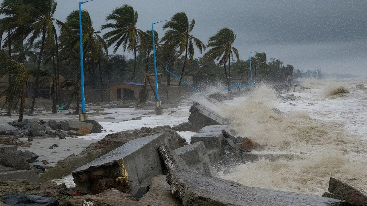
By the time the sun rose on October 28, 2025, thousands of families in coastal Andhra Pradesh had already boarded up windows, packed emergency kits, and moved to government shelters. Cyclone Montha, a Thailand-named storm meaning "fragrant flower," had transformed from a tropical disturbance into a Severe Cyclonic Storm — and it was barreling toward landfall near Kakinada. With winds hitting 100 km/h and gusts up to 110 km/h, the India Meteorological Department (IMD) warned of life-threatening conditions, not just from wind, but from rain so heavy it could drown entire neighborhoods. The storm’s path, confirmed at 5:30 a.m. IST on October 27, showed it was just 560 km off Visakhapatnam, moving northwest at 18 km/h — faster than forecasters initially expected.
Why This Storm Is Different
Most cyclones in the Bay of Bengal fizzle out over land or weaken quickly. Not Cyclone Montha. This one was feeding off unusually warm sea surface temperatures — 31.5°C, nearly 2°C above seasonal average. That’s why the IMD upgraded it so rapidly. And it wasn’t just coastal areas at risk. The storm’s outer bands had already triggered record rainfall in Saurashtra & Kutch on October 27, and by October 28, heavy downpours were lashing Rajasthan, dropping temperatures by 8°C — an odd but telling sign of how far-reaching the system’s influence had become.
"We’ve seen cyclones before," said GNRS Srinivasa Rao, an official at IMD Hyderabad. "But this one carries moisture like a freight train. It’s not just about the wind — it’s about the water that won’t stop falling."
Emergency Response on Overdrive
By Monday evening, Andhra Pradesh had turned into a war room. Chief Minister N Chandrababu Naidu didn’t just issue orders — he demanded results. "No deaths. Not one," he told district collectors during a midnight video call. The state’s disaster response was already in motion: 269 rehabilitation centers opened, stocked with food, water, medicines, and blankets. Thirty National Disaster Response Force (NDRF) teams and 50 State Disaster Response Force (SDRF) units were deployed, with earthmovers and generators pre-positioned in flood-prone zones like Konaseema and West Godavari.
At the Kakinada collectorate, Civil Supplies Minister Nadendla Manohar reviewed real-time data on power outages and water supply disruptions. "We’ve got 72 hours to get this right," he told reporters. "If the power grid fails, we’ve got backup. If roads flood, we’ve got tractors. If people panic, we’ve got loudspeakers and volunteers."
Beyond Andhra: A Ripple Effect
The storm’s shadow stretched far beyond the coast. Odisha braced for its own deluge, with life guards on beaches from Gopalpur to Puri warning swimmers not to go beyond knee-deep water. In Chhattisgarh, officials activated flood gates along the Mahanadi tributaries. Even Tamil Nadu, hundreds of kilometers south, got an orange alert — Chennai’s drainage systems, still recovering from 2023’s floods, were being inspected hourly.
And then there was the ocean. The Indian National Centre for Ocean Information Services (INCOIS) predicted waves between 2 and 4.7 meters along the Andhra coast — enough to sweep away fishing boats, damage jetties, and flood low-lying villages. Over 1,200 fishermen had already returned to shore, their nets stowed, engines turned off. "We’ve lost everything to cyclones before," said veteran fisherman Ramesh Kumar, 58, from Nellore. "This time, we’re not gambling."
What’s Next? The Real Test Begins
Landfall was expected between 8 p.m. and midnight on October 28. But the real danger didn’t end when the eye passed over. The storm’s slow movement — just 15 km/h after landfall — meant prolonged rain. The IMD warned of "isolated extremely heavy rainfall" continuing through October 29, especially in Chhattisgarh and parts of Odisha. That’s when the rivers would swell. That’s when power lines would snap. That’s when the true cost would emerge.
Already, over 120 schools across Visakhapatnam, Anakapalle, and West Godavari had shut down for two days. Mobile medical units were being deployed. The state’s food distribution network, once criticized for delays, was now running like clockwork — 1.8 million ration cards activated for emergency supplies.
Why This Matters to Everyone
Climate scientists at the Indian Institute of Tropical Meteorology say Cyclone Montha fits a troubling pattern: stronger storms, faster intensification, and longer-lasting rains. The Bay of Bengal has warmed by 0.8°C over the last decade — a change that doesn’t sound like much, but turns ordinary cyclones into monsters. This isn’t just an Andhra problem. It’s a warning for every coastal city in India — from Mumbai to Kolkata.
What happened in Kakinada tonight will echo in policy meetings in Delhi next week. If the response works — if no one dies, if infrastructure holds — it becomes a model. If it fails, it becomes a tragedy that could have been prevented.
Frequently Asked Questions
How severe is the rainfall expected in Andhra Pradesh during Cyclone Montha?
The IMD forecasts "isolated extremely heavy rainfall" — over 200 mm in 24 hours — across coastal districts like Kakinada, East Godavari, and Konaseema between October 27 and 29. Some areas may receive over 300 mm, triggering flash floods and landslides. This is the highest rainfall warning level issued since Cyclone Jawad in 2021.
Why is Rajasthan experiencing heavy rain from a storm in the Bay of Bengal?
Cyclone Montha’s outflow has pushed moisture-laden winds northwestward across central India, colliding with cooler air over Rajasthan. This interaction triggered unexpected thunderstorms and a sharp 8°C temperature drop — a rare meteorological phenomenon that underscores how large-scale weather systems can affect regions far from the storm’s core.
What’s the role of the NDRF and SDRF in this disaster response?
The 30 NDRF and 50 SDRF teams are trained for flood rescue, urban search-and-rescue, and medical evacuation. Each team carries inflatable boats, life jackets, and portable medical kits. They’re stationed in high-risk zones like low-lying villages near rivers and coastal marshes, ready to respond within 30 minutes of a distress call — a critical advantage over slower civilian response networks.
Are schools and businesses closed only in Andhra Pradesh?
No. While Andhra Pradesh declared a two-day holiday in its most vulnerable districts, neighboring states like Odisha and Telangana suspended government office operations on October 28. Private schools in Chennai and Bengaluru also closed voluntarily. Many logistics companies halted deliveries to coastal regions, anticipating road closures and port shutdowns.
How does Cyclone Montha compare to past storms in the region?
Montha is the first severe cyclone of the 2025 season and is comparable in intensity to Cyclone Fani (2019) but with a slower movement, increasing flood risk. Unlike Fani, which hit Odisha, Montha’s landfall is closer to Kakinada — a region less prepared for such a powerful system. Wind speeds are similar to Cyclone Gaja (2018), but rainfall projections are 40% higher due to warmer ocean temperatures.
What should residents do if they’re still at home during the storm?
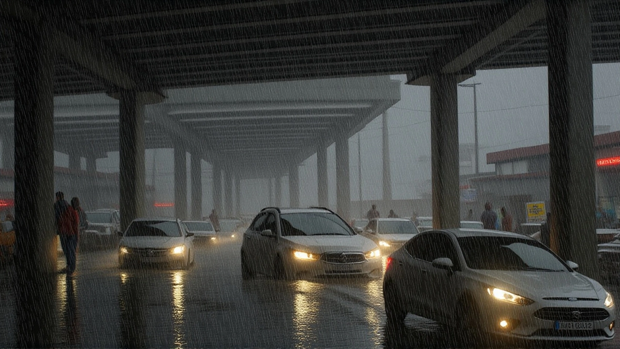
Stay indoors, away from windows. Keep mobile phones charged and use them only for emergencies. Have a battery-powered radio ready to receive updates. Avoid using generators indoors — carbon monoxide poisoning kills more people than flooding during cyclones. If your home is near a river or coast, move to the highest floor immediately. Do not attempt to drive through flooded roads — just 15 cm of water can sweep away a car.